
The Hard Way
Personal Essay & Photos by PAUL KELLY
____________________________
Somehow the darkness crept in quicker than I imagined. Pairs of forward-facing eyes reflect my own light back to me in an eerie look that is both familiar and foreign. With three more miles to go we push through clouds of mosquitoes and unfamiliar terrain, sweating under the weight of our gear. The humidity leaves no question that it is August.
“Monkey eyes look so freaky at night,” Blake said as we stride within a few feet of the primate onlookers. Japan is one of the few islands that have monkeys. They’re only found on the Northern islands of the Japanese archipelago and out to the west in the mountains. Here in Nagano Prefecture there are plenty of monkeys because there are plenty of mountains — especially in Kamikochi National Park.
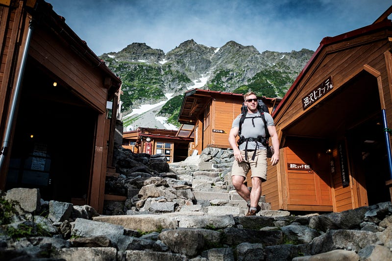
Arriving at Tokusawa Campground we drop our packs, catch our breath and set up the tent. It’s 10 p.m. and we’re already behind by eight hours. There is only one way into the main gate of Kamikochi; you have to catch a bus at Sawando station. No private vehicles are allowed in the park as a measure against pollution. To us, it feels like they’re trying to keep it a secret.

The tricky part for foreigners is that Nagano has more than one Sawando station. Lucky for us, we corrected our error in time. After a few games of charades with the locals and the few Japanese phrases we knew, we found the real Sawando station with minutes to spare before the last bus left at 5:30 p.m. Japan can be a challenging place to navigate when you can’t speak or read the language.
We had been planning this trip for months. Back in June I called him, asking to buy a map for this very four-day backpacking trip. Being the one stationed in Japan he had the best opportunity to purchase a map. “Yeah bro, I’ll pick up the map for Kamikochi area this week and we’ll start planning the route,” Blake said in his typical pseudo-surfer-bro linguistic that has been tainted with a touch of military authority.
I had no reason to doubt him. We met on our first ship, the USS Denver, stationed in Sasebo, Japan back in 2011. We worked long, grueling days as deckhands chipping rust, painting and cleaning toilets for 18 hours a day. We went to special training schools together where we learned to board moving ships and capture them with 8-man teams. We learned weapons, hand-to-hand fighting and how to shoot and rappel at the same time. We had explored countries all over Asia, often getting lost and eating things we didn’t fully understand, much to the amusement of locals. On weekends when we weren’t on deployment we ran mountains and trained hard in the gym. He is my brother — a bond forged in adversity and adventure. Besides, he is a professional navigator for the U.S. Navy — a highly trained sailor who understands accuracy, responsibility and the importance of correct navigational aids.
With the tent erected and dinner cooking, I turn to Blake and ask him to pull out the map so we can check our route for the morning. After digging through his pack for a few minutes the answer is clear without a word spoken — no map.
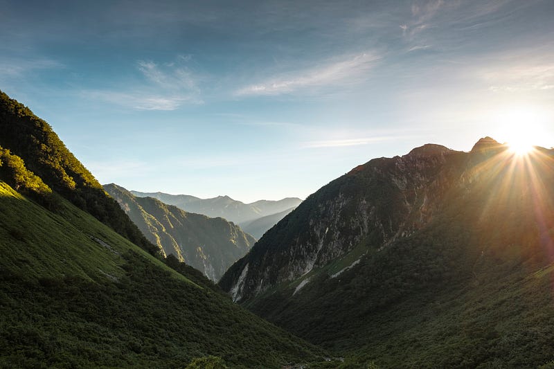
While we had both been stationed in Japan for at least three years, neither of us is fluent in Japanese. We know enough to order food and drinks but we can barely read the signs on the road. Now in Kamikochi National Park — one of the most rugged places in all of Japan — our well-planned trip is coming apart at the seams on Day One.
Kamikochi is Japan’s Yellowstone. The park is comprised of peaks in excess of 10,000 feet with rugged river valleys, wildlife and volcanic activity. Japan has a surprising volume of things, all efficiently crammed into a small space. The terrain is steep, rugged and littered with sharp peaks. Between a few of these peaks on the west side of the Azusa River is the infamous Daikiretto. This famous knife’s edge ridge at 10,000 feet extends from Yarigadake — 10,433 feet, to the summit of Mount Hotaka — 10,465 feet some 6 miles south.
Known as one of the most dangerous hikes in Japan, it also affords some of the most spectacular views. Our plan is to hike a 30-mile loop north through the river valley to the summit of Yarigadake, climb all four peaks on the Daikiretto on our way south, and exit victorious after summiting Hotaka. We will have four days to climb the route with a fifth day for emergencies.
Already a day behind, over packed, illiterate, practically mute and now with no map we have to make an executive decision. Unsure if we’ll even find the trail, let alone our original route.
We make the mature choice.
“Fuck it, we’ll do it live,” Blake said in his best Bill O’Reilly voice. I couldn’t agree more.
“Oh also, do you have a spare water bottle? I left mine on the bus I think,” Blake said. Off to a good start. I hand him my spare bottle, we clean up and go to sleep.
The morning of Day Two greets us with sun and calm weather. After a breakfast of muesli, sardines and some maple Sriracha sauce-bacon provided by Trader Joes, I waste no time accosting Blake.
“Hey man, why don’t you pull out that map and we’ll have a look at the route,” I say with a sly grin. A certain hand gesture and a laugh is all I get as a response. We throw the packs on and continue upriver another 5 miles to Yokoo, arriving in a little under two hours.
Relying on my memory of the route I know we have to cross the river to the west over a large suspension bridge. After we cross this bridge we will climb roughly 4,500 feet to the summit of Yarigadake. We grab a quick snack and some water, pose for a photo on the bridge, and cross the river. So far so good.
A few hours pass without much elevation change. I begin to sense something is wrong. The topography feels more like Iowa than a 10,000-foot peak. We wave down a passing Japanese hiker and try our best not to sound like a couple of 3-year-olds lost in the mall.
“Sumimassen. Daikiretto wa doko desu ka?” Blake said. The man gives us a look like we just lost a bet. He points way off in the distance, to the north. The Daikiretto is on the other side of those mountains. It turns out we are climbing the route backward — “the hard way” the man tells us repeatedly. We bow and say “arigatou.”
We decide we’re OK with the hard way. It seems to be the way we do everything else so why change now? Besides, if we turn around and go look for where we went wrong we’ll be hiking the “dark way” — for the second time. We shoulder our packs and buckle in for whatever “the hard way” is going to throw at us.
More hours pass. The man was right.
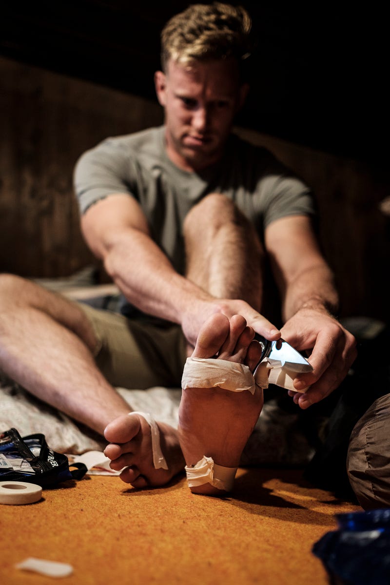
“I feel like climbing 4,000 feet of ladders would be easier than this,” Blake said between gasps. We stop for a break and he pulls off his boots and begins to treat his quarter-size blisters that have been growing all day. For us sea level dwellers, 6,500 feet of rugged elevation feels like we’re stuck on top of K2. Despite being winded myself, I waste no time helping him feel better.
“Hey man how much farther do we have to go? Why don’t you pull out that map?” I say with the same wry smile that has graced my sweaty face the entire trip. Blake is too tired to shoot me an equally sharp comment, but laughs anyway. We press on toward wherever “the hard way” meets the summit.
More hours of grueling climbing pass. We come out to a clearing where we can finally see some of the surrounding peaks. At the bottom of a rock staircase we catch our breath as a small, elderly woman catches up to us. Maybe she also forgot her map?
“Konnichiwa,” we say with a bow. She returns the greeting with a bright smile. Through a mix of the usual hand gestures, broken Japanese and broken English we learn that she is 78 — and faster than us. She has climbed Kita-Ho — a spear tip peak to our north — no less than 15 times. This is her version of retirement. Apparently, no one told her that this was “the hard way.”
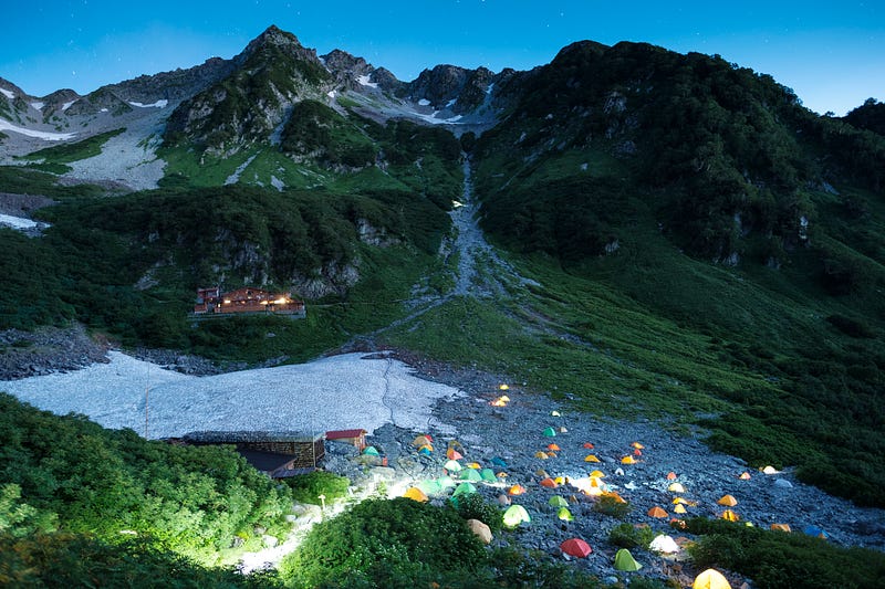
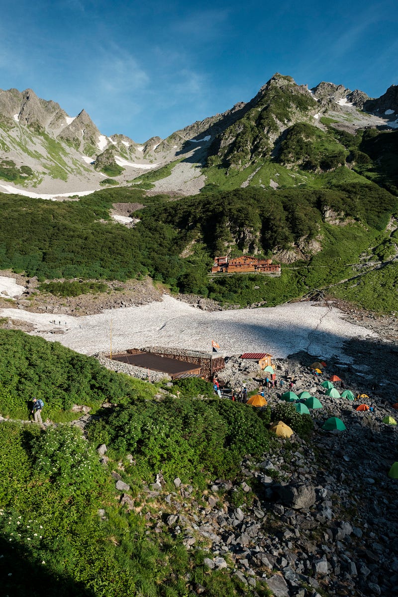
We also learn from her that there is a hut nearby. Karuizawa hut becomes our new destination for Day Two. Within an hour we reach the hut and enter into the small enclave that sits in the base of an amphitheater of 10,000-foot peaks.
We find a picnic table with a view on the sun deck and drop our packs. Sriracha maple bacon fills my mouth with joy. The hard way indeed. Now in a place that has a map, we study hard to learn our mistakes, and wager if we have the time to climb the original route we had planned.
“We missed the correct bridge by about 2 miles back at Yokoo,” Blake said with a touch of frustration in his voice. All we had to do was take a few more steps north past the bridge we crossed and we would be standing on top of Yarigadake on route and on schedule — not on “the hard way.” We share a laugh at the circumstances because it’s all we can do at the time.
Just as we start to plan an alternate route up Kita-Ho people begin to gather around a monitor inside the hut. Blake and I take notice just in time. There is a typhoon headed directly for us. It will arrive tomorrow around lunch time. It seems this trip was doomed from the beginning. Do we have enough time to wake up early, summit Kita-Ho and get down before the typhoon arrives?
Absolutely smoked, we go to bed immediately following dinner at about 7:30 p.m. We rise the next morning around 4 a.m. and head outside to check the conditions. The sky is like a dark ocean of stars. There is barely a breeze. Could there really be a typhoon about to make landfall?
After some discussion we decide that getting caught in a typhoon at 10,000 feet would be a bad call. We plan to hike down soon and try to beat the storm. Sensing that there’s no rush to climb a mountain, Blake grabs a coffee and we sit down to watch the sun rise.
It turns out meteorologists get paid even if they’re wrong. Somehow the typhoon has sped up and will hit us two hours earlier than planned. Blake and I eat fast, pack our gear and start our run down the trail. About 2 miles in we notice clouds gathering overhead. We also see that we’ve picked up a tail. A local father and son have decided to use us for keeping pace. They are also trying to beat the storm. Out of breath when we stop, all they can muster is “gaijin haiyai” or “fast foreigners.”
We stop only when we have to. We are covering the same distance that took us two days in one push today. Arriving back at Yokoo we cross the bridge. Immediately to our north is a sign in English characters: “Yarigadake Summit” with an arrow.
“They must have put that in overnight,” I say to Blake with a grumble. We push on, feeling beat with blistered feet.
The more miles we cover the darker the sky grows. Within a mile of the bus station the sky begins to pelt us with sporadic rain drops. We slip under the covered bus station just as the typhoon unleashes sheets of rain. We are exhausted, but dry. Finally, at the end of the journey we begin to relax. The hard way is over. Or so we think.
Arriving back at Sawando station we change into some clean clothes, toss our packs in the back and start our drive back to Atsugi area. My stomach does its best to tie itself in a knot. We stop for dinner at CoCo Curry House. Blake downs a huge plate of chicken and curry while I make three more trips to the toilet.
“Maybe you should eat something,” Blake encourages me.
“Maybe you should shut the hell up,” I snap. We are both frayed, and ready to be home.
The typhoon rages on outside the car as we accelerate onto the highway. My stomach settles enough for me to sleep for an hour. I drift into strange hallucinations, but am woken by an abrupt stop.
“Where are we?” I ask.
“It looks like the highway is closed,” Blake said. We have no choice but to exit, along with every other person in Japan who lives within 100 miles of Tokyo. The back roads are absolutely packed. We travel 5 miles in four hours. After scouring the map on my phone for an hour I piece together an alternate route around the traffic. We turn off the main road, onto a winding single lane road that takes us up through the mountains in Sagamiko area.
The sky is puking rain. The road is paved but only about the width of an American sidewalk. It is still two-way traffic as we discover on one corner. Wild boars dart across the road every once in a while. Turn after turn blur together. The mixture of lights and turns and exhaustion make it feel like we’re stuck on Willy Wonka’s roller coaster as my peripheral vision blurs. Eventually, some hours later we come out the other end, close to home. We pull into the driveway at 1:30 a.m. Eleven hours to travel 150 miles.
We leave the bags in the car for tomorrow, shower and go to sleep.
The next day we wake up late. Over breakfast we begin to talk about how we can do better the next time we go to Kamikochi.
The hard way can’t keep us down.